


Chaos in the Skies: A Wild Weather Weekend Grips the USA
March 15, 2025 | By Samantha Carter, Weather Correspondent
The United States is no stranger to dramatic weather, but this weekend, Mother Nature is pulling out all the stops. From blinding blizzards in the Upper Midwest to a rare “thunder-dust” storm in the Southwest, and a line of ferocious thunderstorms threatening the Southeast, millions of Americans are bracing for a turbulent few days. Here’s the latest on this coast-to-coast weather rollercoaster—and what it means for you.
www.skyneglobalnews.orgSkynetglobalnews.org
Blizzard Blitzes the Heartland
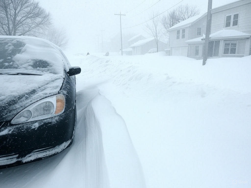
In the Upper Midwest, a powerful low-pressure system has unleashed a monster blizzard that’s turning highways into ice rinks and neighborhoods into winter fortresses. As of early Saturday, March 15, Minneapolis reported 14 inches of snow in just 12 hours, with wind gusts topping 50 mph creating near-whiteout conditions. The National Weather Service (NWS) has issued Blizzard Warnings from eastern North Dakota down to northern Iowa, urging residents to stay off the rpads.
“It’s like living in a snow globe someone keeps shaking,” said Minneapolis resident Tara Jensen, who’s been shoveling her driveway since dawn. Forecasters say the storm could dump up to 20 inches by Sunday night, with temperatures plunging to the single digits. Power outages are already creeping up as ice-laden branches snap under the weight.
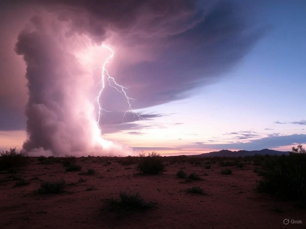
Thunder-Dust: A Southwest Spectacle
Meanwhile, the Southwest is witnessing a bizarre phenomenon dubbed a “thunder-dust” storm. High winds whipping across New Mexico and Arizona have kicked up massive dust clouds, reducing visibility to mere feet in places like Albuquerque and Tucson. But here’s the kicker: embedded thunderstorms are sparking lightning within the swirling haze, creating an eerie, apocalyptic scene.
“It’s like something out of a sci-fi movie,” said Tucson local Miguel Ortiz, who captured video of lightning flashing through a reddish-brown dust wall. The NWS warns that gusts up to 60 mph could topple power lines and fan isolated wildfires, especially in bone-dry regions. Air quality alerts are in effect, with health officials advising residents to stay indoors and seal windows.
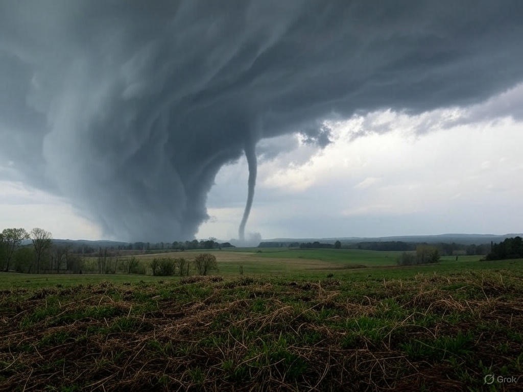
Southeast Under Siege: Tornado Threat Looms
Down in the Southeast, the mood is tense as a warm, humid air mass collides with a cold front, setting the stage for severe thunderstorms and possible tornadoes. Alabama, Mississippi, and Georgia are in the crosshairs, with the Storm Prediction Center issuing a “Moderate Risk” alert for Saturday afternoon through Sunday morning. Forecasters say conditions are ripe for long-track tornadoes, destructive hail, and winds exceeding 70 mph.
In Birmingham, schools canceled weekend events, and residents are stocking up on supplies. “We’ve got our safe room ready,” said local teacher Emily Hayes. “After last year’s storms, we’re not taking chances.” The NWS advises keeping phones charged and monitoring local alerts as the system moves eastward.
What’s Next?
This chaotic weather pattern stems from a deep jet stream dip that’s funneling cold air south and pulling warm, moist air north—an atmospheric recipe for extremes. By Monday, the Midwest blizzard should taper off, though bitter cold will linger. The Southwest’s dust storms are expected to weaken as winds subside, while the Southeast’s severe weather could push into the Carolinas before fizzling out.
For now, safety is key. Check road conditions before traveling, keep emergency kits stocked, and stay tuned to updates. Whether you’re shoveling snow, dodging dust, or watching the skies, this weekend is a reminder of nature’s wild side—and the resilience of Americans who weather it.
Stay safe out there, USA! Share your weather stories with us in the comments below.
The Upper Midwest is locked in a deep freeze as a ferocious blizzard roars through, driven by a sprawling low-pressure system parked over the Great Plains. Minneapolis clocked 14 inches of snow by Saturday morning, March 15, with drifts piling higher as 50 mph gusts sculpt a wintry wasteland. The National Weather Service (NWS) has hoisted Blizzard Warnings from North Dakota to northern Iowa, where wind chills could plummet to -20°F by Sunday. Adding to the chaos, a rare “lake-effect snow burst” off Lake Superior is dumping extra inches on Duluth, snarling rescue efforts.
“It’s relentless—like the storm’s got a personal grudge,” said Tara Jensen, a Minneapolis local battling the drifts. Power companies report over 50,000 outages as ice-coated lines buckle, and schools across the region have shuttered through Monday. The NWS warns that travel could remain treacherous well into next week as cleanup begins.